
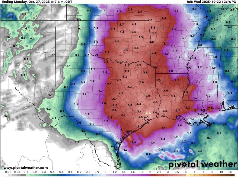
(Katy, Texas) Harris County ESD No. 48 Fire Department is monitoring a strong storm system expected to impact the region late Friday through Saturday, bringing widespread rainfall and possible strong thunderstorms. While this rainfall will help reduce fire danger and dry conditions, residents should remain alert for localized street flooding and changing weather patterns.
Elevated Fire Weather
Ahead of the storm, a cool and dry air mass continues to influence the region. Afternoon humidity levels are expected to fall to 25–35%, with winds of 10–20 mph. These conditions, combined with extremely dry grass and vegetation, create a high fire danger.
Residents are urged to avoid outdoor burning, properly dispose of cigarettes, and avoid parking vehicles on dry grass.
Storm Outlook
A large upper-level low pressure system moving into Texas Friday will bring an increase in moisture and lift, leading to showers and a few strong thunderstorms late Friday into Saturday. Widespread rainfall of 2–3 inches is likely, with isolated higher totals possible. While the dry ground should help limit major flooding, street flooding may occur in poor drainage areas.
Preparedness Tips
Residents are encouraged to:
- Monitor trusted weather updates.
- Secure outdoor items ahead of the storm.
- Avoid driving through flooded roads — Turn Around, Don’t Drown.
This rainfall will provide much-needed relief to ongoing dry conditions, helping to lower the region’s wildfire risk. HCESD No. 48 will continue to monitor weather developments and share updates as conditions change.